Monday, January 19, 2009

Mangrove Forests in Bali

mangrove treeMangrove forest are continuously being rehabilitated

Where nature tourism is integrated with conservation efforts

Indonesia, as a tropical island national, has around 17,500 islands with a coastline totaling 81,000 kilometers – a distance equal to twice the circumference of the earth. With this extensive coastline, Indonesia has the world’s greatest mangrove forests: 4.5 million hectares, or a quarter of the world’s total. Bali alone has 2,215 hectares of mangrove forest in various places, and one of the largest is in the Tanjung Benoa area. Mangrove (in Indonesian, bakau) is the name used for a wide variety of trees that grow in seawater tideland areas. Indonesia has around 89 species of mangroves, 30 of which are found in Bali.

bali mangroveUntil recently, the public has thought of mangroves as no more than a type of coastal tree with various economic uses. Actually, mangrove forest have many functions, such as protecting the coasts from abrasion by waves, preventing erosion of soil that then washes away into the sea, providing a habitat for marine biota, capturing CO2 and producing O2 - oxygen – which is needed by humans and other living creatures. Mangrove forests can also be developed as ecotourism venues, with the mission of promoting proper management and conservation of the environment.

The journey started at the Mangrove Information Center (MIC), founded in 1993 by the Department of Forestry with the assistance of the Japan International Cooperation Agency (JICA) and located at Jalan Bypass Ngurah Rai, km 21, just 15 minutes from Kuta, or 20 minutes from the center of Denpasar. As you enter the area, you encounter a green panorama of mangrove forests along both sides of the road. This green belt plays an important role as the “lungs” of the city. The project emerged from concern over the large-scale destruction of these forests. Mangrove forests have rapidly been degraded through conversion into fish or shrimp cultivation ponds, rice fields, harbors, and industrial zones, and by excessive felling for various purposes. The project provides a venue for training, outreach, and education regarding sustainable management of the mangrove forest ecosystem, and also for ecotourism activities.

Head toward the Mangrove Trail, first, there is mangrove nursery, which provides seedlings for the mangrove forest rehabilitation process. Next is the Touch Pool, where visitors, students and families can learn about the environment through direct experience. There are two trails to choose from - a short route of about one hour, and the other, a longer route of nearly two hours.

mangrove trailStarting from the entry point to the Mangrove Trail, at a small structure called the Pond Heron Hut, the path is comprised of sturdy bridges made of Borneo ironwood (ulin), to prevent damage to the environment. The Mangrove Trail is 2150 meters long, 1850 meters of which is wooden bridges. Posted at the trailhead are a map of the trail and a notice reminding visitors about what activities are prohibited in the area. The trail is clearly marked at all points, so there is no risk of getting lost.

A walk along the wooden bridges, enjoying the greenery of the mangrove forests, is very pleasant indeed; it provides both recreation and an excellent opportunity for children to learn to love nature. Signs along the trail provide information about the various types of mangrove trees and the other creatures that live in the forest. There is also a tidy wooden rest shelter.

The mangrove roots that rise high above the surface of the marsh in artistic patterns play an important role in preventing coastal abrasion and soil erosion. Unfortunately, the area’s natural beauty is marred by certain people’s littering.

When the tide goes out, dozens of crabs can be seen scurrying along the ground, popping into holes as we approach and emerging again after we have passed. It’s not surprising to see such a variety of marine species there, because the mangrove forest serves as a nursery ground, feeding ground, and spawning ground for many types of fish, shrimp, crabs and other species.

mangroveOld mangrove trees grace the Benoa Bali port

Several creeks pass through the forest, with bridges crossing over them. These streams are an ideal place to explore the mangrove forests. The Mangrove Information Centre Schedules regular boat trips to explore the forests.

bali mangroveWooden bridges are ideal for trekking

There are also several lookout towers, from which we can observe the forest and its birds and mammals. When the weather is clear, one can also see mountains in the distance – Gunung Agung and Gunung Batukaru. You can also watch the various species of birds and mammals, including storks, kingfishers and monitor lizards. It’s a perfect place for those who enjoy bird watching, or just to rest for a while after the walk. Gentle breezes relieve your fatigue and revive you to continue the trek.

The functions and benefits of the mangrove forests can no longer be ignored and it is essential that we preserve them. The many problems that the forests face, such as trash and land conversion, must be mitigated immediately, by raising public awareness. Proper synergy between humans and their natural environment will create tremendous benefits for all of us.

Fore more information, contact: Mangrove Information Centre (MIC) Jl. Bypass Ngurah Rai km. 21, Suwung Kauh, Denpasar, Indonesia
Tel: 62-361-726969, 726546, 728966

Fax: 62-361-710473

Text by I.B. Andi Sucirta. Source: Garuda Mgz

West Sumatera

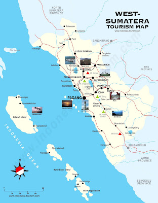
west sumatra mapWest Sumatera tourism map

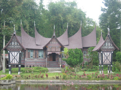
The house or building with specific roof shape of Minang (Minang term: Bagonjong house) is common scene here. This is West Sumatera, a province with excessively tremendous panoramas.

Rumah GadangWest Sumatera traditional house

Walking along step by step in Minang land, West Sumatera, feels like enjoying series of amazing natural beauties. Beach, lake, bay, highland, canyon even mountain, become natural wealth that it’s superb hard to find matches. At certain point in West Sumatera, you can watch views maximally: it’s called ‘Panorama’. In cities, such as Bukittinggi and others, there are Panorama’s with magnificent views.

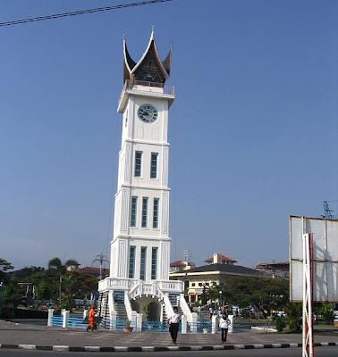
Jam Gadang Jam Gadang (Gadang Watch) - Bukittinggi, West Sumatera

Bukittinggi
What an attractive city with its popular icon of Jam Gadang (Gadang Watch) it is. With its width of 25.24 km2 and surrounded by three mountains, Merapi, Singgalang, and Sago, makes Bukittinggi becoming a very special location. At Lubang Jepang panorama, there are comfortable place to enjoy views of Sianok Canyon, Singgalang and Merapi Mountain, including tower to get all sight from higher distance, and souvenir shops which offer things with relatively cheap price.

Padang City
Padang city by its 694.96 km2 width becomes one of West Sumatera’s large city. Moreover the city rich of natural sights from lowland until highland views. Your adventure should begin at sunrise. Bring your vehicle to Siti Nurbaya bridge: a curved big bridge; to get a view of ships with the background of hills. At the edge of city main roads stand various trees with green, yellow, red and many more leafs, moving our heart more glorifies God.

Teluk Bayur PortTeluk Bayur - West Sumatera

Teluk Bayur is a bay in Padang that its magical view can be seen from side road which beaded to Bungus. The dent of the bay combined beautifully with blue sky, and ships which go back and forth. At certain point, little tame monkeys, lively moved near peanut sellers inviting anybody to come near.

Padang Panjang
Padang Panjang is located between Bukittinggi and Padang. Merapi and Singgalang Mountain decorated by climbing down fog is the city’s main natural sight.

Padang RestaurantPadang restaurant

Besides Padang original food there are also Javanese and Sunda’s food available in few shops. Train station that once in a while is visited by classic train can be found here. Islamic atmosphere is quite strong among the city, so Padang Panjang has a special name The Veranda of Mekah.

Lake Sight
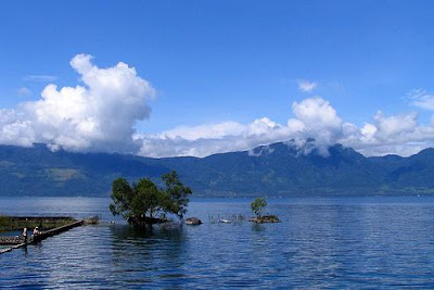
Some amazing big lakes in West Sumatera located near Solok. Diatas, Dibawah, Singkarak Lake and others show each charms. Diatas Lake is one of lake which its natural originally kept well. Its surrounding area has enormous cabbages plant as main agricultural crops. Unfortunately, in ordinary days, only very few people visits.

singkarak lakeLake Singkarak (Danau Singkarak) - West Sumatra, located between the cities of Padang Panjang and Solok and have appoximately 21 km long and 7 km wide

Find a nearest ‘Panorama’, which completely view of Diatas and Dibawah Lake are appeared. Bright weather with white cloud paraded united with lakes and hills will makes you impressed.

Now, is up to you whether you have enough time to enjoy all West Sumatera sights or not.

A Little Pieces from a Beautiful Indonesia View


Exotic, charming and wonderfully embracing, Indonesia is one of Southeast Asia’s Top Travel Destinations. It has one of the world's greatest tourism destinations in Bali. With the capital city Jakarta, it is a very interesting country to visit.

With a population of over 234 million people, it makes Indonesia is the world's fourth most populous country and the most populous Muslim-majority nation. It is also known as the world's largest archipelagic state. Comprising about 17,508 islands (including big and small islands). The main islands are Kalimantan (539,460 km2), Sumatera (425,606 km2), Irian Jaya (421,981 km2), Sulawesi (174,219 km2), and Java (129,187 km2). Indonesia shares its land borders with Papua New Guinea, Malaysia, and East Timor. Indonesia is also adjacent to Australia to the south, Singapore to the north-west, Philipines to the north-east, and the Indian territory of the Andaman and Nicobar Islands.

Indonesia truly is an amazing place with so much to offer tourists. The regular and most popular destinations of Bali, Lombok, Jakarta, Bandung, Yogyakarta, Batam, Padang, Medan etc are only small part of the country and there are so many more undiscovered charms to be found. Explore more about the unique of Indonesia multi culture, give you some ideas of where to go and what to do. Wherever you go you can be assure that the people will welcome you with open arms, and sparkle smiles, and you may well quickly fall in love with many of the sights and diverse regions that Indonesia has to offer.

Art and culture resources belong to humanity as a whole and those of Indonesian are explicit expressions of life, born out of an extraordinary rich cultural heritage which have become a garden of Eden for social scientists and culture vultures; a veritable treasure chest of tradition waiting to be opened.

Every nation requires a heritage with which people continually interact cross culturally as well as cross generations, one which fuses past, present and future and Indonesia is home to tremendous and glorious legacies of the past, be they cultural or natural heritages. So, be the witness of your own.

People may say that there is only one world and it is getting smaller; but when comes to Indonesian marine resource, there seems to be a totally different world. Once under the waves a whole new world is waiting magnificent multi colored sea gardens, enormous coral, and myriad technocolored fish, wild dolphins and turtles to mention a few. So magnificent, that you definitely forget about time.

Our tropical forests bestowed on us by God, are the envy of many nations because of their abundant bio diversity. They have been waiting there for us to experience for ourselves, first hand, the miracles of Mother nature, previously only known to use through text books.

One of the legendary indigenous plants proudly displayed in botanical gardens around the world is the “bunga bangkai” (Rafflesia Arnoldi), display, reaching almost 1.5 meters in diameter, you can wonder at the spectacular spots on its giant petals. But the most amazing quality of the bunga bangkai is its nocturnal scent, said to resemble that of a corpse! That’s how it got its nick name.

Incomparable and unique, only our beautiful tropical forests offer this breath-taking sight, it truly is a pride of our nation.


Excotix Kakaban lake - Indonesia

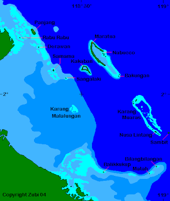
borneo mapsMap of the northern part of Borneo (Sabah, Sarawak, East-Kalimantan)

Justly celebrated as a biological paradise, Kakaban Island (Pulau Kakaban) is a truly awe-inspiring place. Part of the Kepulauan Sangalaki Marine Wildlife Reserve off the coast of East Kalimantan, Kakaban is a coral atoll that was uplifted by geological forces thousands of years ago, turning the lagoon into a land-locked lake. The five-square-kilometer body of water, surrounded of the interior of the island. In the local dialect Kakaban means "hug" as the island hugs the lake from the surrounding sea-water.

kakaban location mapMap of the dive islands of Sangalaki, Derawan, Nabucco, Manatua and Kakaban in the Berau Archipelago (East-Kalimantan, Borneo, Indonesia)

kakaban jellyfishFrom the surface, Kakaban Lake (Danau Kakaban) looks like a typical freshwater lake, but below there is an abundance of colorful marine life. In fact, the lake is considered the world’s largest and most diverse jellyfish lake and includes at least four species of sting-less jellyfish. The mystery of how the lake’s plant and animal life were able to survive in this isolated system is a subject that marine scientists and geologist still argue about. The sea surrounding Kakaban Island is also home to large shoals of Barracuda as well as blue fined tunas and big sharks. You can do a drift dive but a grab line has been permanently secured at 24 m across a relatively flat area on the upcurrent side of the point. Currents can be fierce with down currents.

Blue light cave is for experienced divers since the exit is quite deep. The cave starts at a hole accessible at low tide on the top of the wall at 2 meters and descends through a narrow chimney. At about 21 meters the chimney opens into a large cavern with the bottom at 30 meters. Swimming along the ceiling of the cave for about 120m is also possible and as you approach the exit of the cave, the blue light of the sea can be seen. The exit is a long vertical crack in the wall and about 2 meters wide which lies at 44 meters, there is also another exit at 64 meters. The dive is finished on the wall.

kakaban lakeThe island is uninhabited except for fishermen who use the island as transit stop. However, Indonesia’s Ministry of marine & Fisheries is keen to encourage tourism development in the area; diving tourism being the most obvious segment to promote.

How to get there
To reach Kakaban island, you first take a plane from Balikpapan to Tg.Redep, the capital of Berau district, East Kalimantan. You can then take a speedboat to reach Kakaban island through Derawan and Sangkali islands in 20 to 30 minutes. Best months are April to December.

Island for let
kakaban divingA once-in-a-lifetime opportunity exists to invest in your own slice of paradise in the most culturally and ecologically diverse country in the world. Indonesia launched a pilot project to encourage investment involving 100 islands, including Kakaban, in the archipelago for lease periods of up to 85 years. Already 68 of the 100 islands have been catalogues, with the Ministry in the process of developing a price index, which includes accessibility to other countries, accessibility of the island itself, such as ports or landing strips, and then infrastructure, including availability of water. Investment in these small islands can take the following forms; mariculture, tourism, fishing, fresh water procurement, agriculture, animal husbandry, plantations and energy and mineral resources.

Kakaban Lake


Kakaban Lake is located on the uninhabited island of Kakaban, which is part of the Derawan Island group in the Sulawesi sea. The lake was originally the lagoon of an atoll, formed by corals over a period of two million years. As a result of movements in the earth's crust the coral reef was raised above the sea level, trapping 5 km2 of seawater within a 50 meter high ridge, effectively creating a landlocked marine lake.

Where is Kakaban?

Lake Kakaban is located on the uninhabited island of Kakaban, which is part of the Derawan Island group in the Sulawesi sea. The lake was originally the lagoon of an atoll, formed by corals over a period of two million years. As a result of movements in the earth's crust the coral reef was raised above the sea level, trapping 5 km2 of seawater within a 50 meter high ridge, effectively creating a landlocked marine lake.

The lake is surrounded by a narrow mangrove belt and the entire island is covered with dense tropical vegetation. The coastline of Kakaban Island is encircled by a steeply sloping coral reef.

Why is Kakaban Lake unique?

The organisms found in the lake are originally seawater species such as marine algae, sea anemones, jellyfish, sponges, sea cucumbers, crabs, and several small fish species. Seawater, which seems to enter the lake through small cracks and crevices in the surrounding reef rock, is diluted with rain water, to produce a brackish water environment. Over thousands of years the inhabitants of the lake have adapted to their unusual environment. No large channels or connecting caves have been discovered, so no larger animals have been able to enter or leave the lake for thousands of years. Marine scientists are still trying to solve the mystery of how the isolated and fragile lake ecosystem supports the requirements of its plant and animal communities. Only one other similar lake ecosystem is known; it is found on Palau in Micronesia, about 1000 km east of the Philippines.

The plant and animal species of Kakaban Lake

About three species of the calcium carbonate-producing green alga, Halimeda, cover the bottom of the shallow areas of the lake. The roots of the surrounding mangrove belt provide a habitat for tunicates, sponges, tube worms, bivalves, crustaceans, sea anemones, sea cucumbers, several species of sea snakes, cardinal fish, and at least five known species of gobies. Four species of jellyfish (Cassiopeia ornata, Mastigias papua, Aurelia aurita and Tripedalia cystophora) are also found in Kakaban. Cassiopeia or the "Upside-down" jellyfish can be found lying on its back in shallow parts of the lake. This behavior exposes the jellyfish's symbiotic algae to the sunlight, and thus enable it to produce its food. A jellyfish-eating sea anemone is another interesting inhabitant of Kakaban Lake. This anemone has lost its symbiotic green algae, or zooxanthellae, so it appears white in color.

The benefits of eco-tourism

Kakaban Lake is a unique phenomenon and it attracts its share of eco-tourism. However, its tourism potential is relatively under-developed when compared with the situation in Palau. The 'Jellyfish Lakes' of Palau are visited by more than 30,000 people each year (this is double the population of the Palau islands). If Kakaban Lake could attract even 10 percent of this number of visitors, the revenue potential would be considerable. A visitor's fee of US$ 7.00 per person would bring in US$ 21,000 or 172 Million Rupiah per year. Transport, accommodation and other services would bring additional revenues.

Threats from tourism

While tourism offers opportunities for development in this remote area of Indonesia precautions must be taken to safeguard Kakaban Lake's unique environment. The dangers of unrestricted tourism are many: pollution, increased sedimentation and physical damage caused by the feet and hands of snorklers, habitat disturbances as a result of the use of outboard engines on the lake. An uncontrolled increase in visitor numbers without a code of conduct for sustainable tourism and without a zonation scheme for different lake areas is likely to result in physical damage, particularly in the shallow areas of the lake. Experiences in Palau show how fast such a negative impact can take place; excessive damage there led to a law forbidding the use of snorkeling fins in the lake. Recent tourism-related activities on Kakaban already provide several examples of such negative impacts:
Wood for planned cottages and 147 m of wooden walkways has apparently been cut in the Kakaban forest close to the lake.
Two boats, which will supposedly be powered by outboard engines, are being built on the island in order to take the tourists around the lake and to facilitate water supply of the resort.
According to unconfirmed reports up to 70 Hawksbill turtles have been released into the lake. They are no natural part of the lake ecosystem and may cause another threat for the fragile balance among the living organisms in the lake and to tourism, since the turtles feed on sponges and other invertebrates, which live attached to the mangrove roots and represent one of the major attractions for underwater photographers and snorklers.
The first signs of waste and litter can be found close to the walkway and in the "developed" area of the lake. The sewage and waste treatment of a proposed tourism facility would deserve special attention in order to avoid additional pollution of the lake.
An uncontrolled increase in visitor numbers without a sustainable code of conduct for sustainable tourism and without a zonation scheme for different lake areas will lead to a fast increase of physical damage to the unique animal and plant communities living in the shallow areas around the lake. Experiences made in Palau showed how fast such a negative impact can take place and led for example to a law against the use of snorkeling fins in the lake to decrease damage.

Solutions

With increasing tourist numbers, the potential negative impact on the lake ecosystem will become a major concern for the local government. In order to ensure sustainable use and long term profit, a well-implemented management plan for this national asset is of prior importance. If new tourism facilities are to be developed, an environmental impact assessment or "AMDAL" is of prior importance in order to determine likely impacts of resort development and construction.
Questions, such as carrying capacity, visitor quotas or zonation schemes may be addressed, before negative impacts become apparent.
A zoning plan would be an appropriate method to differentiate among areas, which may be allocated for tourism and tourism infrastructure, sustainable use by local communities, research and conservation.
The success of any management plan depends critically on the involvement of the local coastal communities, local NGOs, the private sector and scientists of Universitas Mulawarman in Samarinda in a multistakeholder planning process. The careful establishment of tourism facilities on the surrounding islands instead of on Kakaban and the development of a quota system for visitor numbers could ensure long term benefits to all stakeholders on regional, provincial, national and international levels

Kakaban lake Jellyfish

Kakaban Jellyfish

Tuesday, January 13, 2009

Dracaena Cinnabari


Dracaena Cinnabari


See... Feel like out of earth..

Monday, January 12, 2009

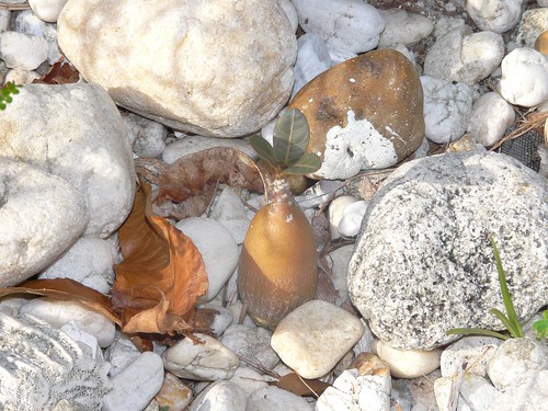
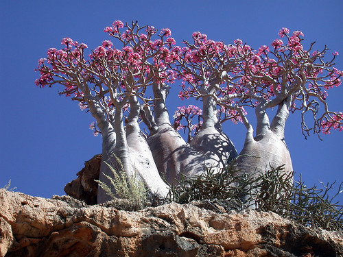
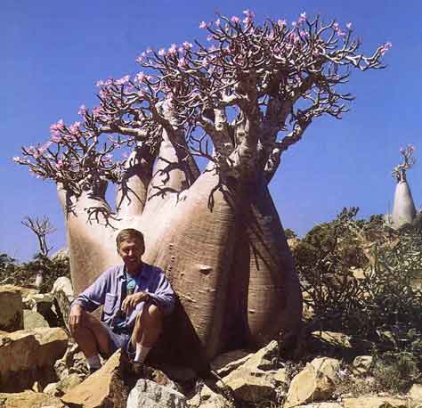
ARABICUM SOCOTRANUM

SOCOTRANUM
SOCOTRANUM
SOCOTRANUM
SOCOTRANUM
SOCOTRANUM
SOCOTRANUM


SOCOTRANUM
SOCOTRANUM
SOCOTRANUM

Adansonia

baobabScientific classification
Kingdom : Plantae
(unranked): Angiosperms
(unranked): Eudicots
(unranked): Rosids
Order: Malvales
Family: Malvaceae
Genus: Adansonia L.
Baobab is the common name of a genus (Adansonia) containing eight species of trees, native to Madagascar (having six species), mainland Africa and Australia (one species in each). The mainland African species also occurs on Madagascar, but it is not a native of that country.

Other common names include boab, boaboa, bottle tree, upside-down tree, and monkey bread tree. The species reach heights of 5 to 30 metres (16 to 98 ft) and trunk diameters of 7 to 11 metres (23 to 36 ft). An African Baobab specimen in Limpopo Province, South Africa, often considered the largest example alive, has a circumference of 47 metres (150 ft) and an average diameter of 15 metres (49 ft).[1]

Some baobabs are reputed to be many thousands of years old, which is difficult to verify as the wood does not produce annual growth rings, though radiocarbon dating may be able to provide age data.

The Malagasy species are important components of the Madagascar dry deciduous forests. Within that biome, A. madagascariensis and A. rubrostipa occur specifically in the Anjajavy Forest, sometimes growing out of the tsingy limestone itself.

Beginning in 2008, there has been increasing interest for developing baobab as a nutrient-rich raw material for consumer products.


Adansonia
baobab
fosil tree